This is by no means a complete list but these are some of the better web apps out there in terms of functionality and ease of use. Although they differ slightly in how you choose the location you want to know the elevation for, they are all easy to use and are relatively user-friendly. It looks like they all rely on Google’s mapping API so the accuracy should be the same for all of them. It is also interesting to note that they not only give you the elevations for land areas but also a depth (bathymetry data) for if you click on a position in the ocean. It might be interesting to see how deep your favorite fishing spot is!


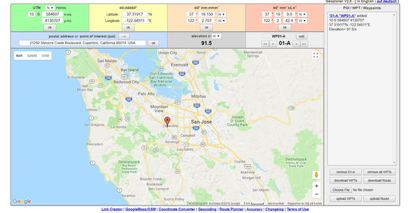
Geoplanner lets you download a file with your chosen elevation points. This could be useful for adding waypoints to your GPS or collection your own elevation data to use with other software programmes. You can also upload data to this web app
http://veloroutes.org/elevation

This last web map can be used to find elevation via an address, you can also choose the between feet and meters. This web app also lets the user select points along a route and visualize the change in elevation along your chosen path. This data available to download as an image and as a file for use in other applications.
This may be overkill but I wanted to include this short video so that you could get an idea of what the code looks like behind these kinds of google maps.
Just in case you discover that the elevation from these web maps does not match with elevation data from other sources. Here is a little information on why that might be.
In order to calculate elevation for a given location, we need to have a model of the earth surface. These models are often a very generalized simple because the greater the complexity and there for the accuracy of this kind of model the model resources it requires in terms of storage and computing power in order to calculate the elevation at a given location. So elevation at a position will change depending on the model of the world ( datum ) used.
This video explains a little more about datums and how they work
https://www.youtube.com/embed/xKGlMp__jog?rel=0
